What is the West Marin Visioning?
| In short, this project is: |
|---|
|
The West Marin Visioning initiative is a community-driven effort to define a shared, long-term vision for the future of West Marin. This collaborative process will bring together community members, businesses, community organizations, and public agencies to define priorities that support a resilient environment, a thriving local economy, and vibrant communities.
This initiative is part of Marin County’s broader commitment to Community and Economic Vitality, a key priority of the Board of Supervisors.
The resulting vision will serve as a guiding framework for future planning, investment, and policy discussions, helping ensure that decisions reflect community values while responding to ever changing conditions.
Para obtener información en español, busque la flechita donde dice “English” más arriba para cambiar el idioma de esta página web, o contactenos aquí.
What is the purpose of the West Marin Visioning?
| This project will aim to: |
|---|
|
West Marin is a unique and interconnected region with distinct communities, strong local identity, and significant environmental resources.
The vision will help align County decisions and investments with community priorities. It is designed to coordinate (not duplicate) existing and past efforts and create a unified direction for West Marin.
This initiative is primarily a public outreach and engagement process that will result in a clear and accessible vision document.
What area does this project cover?
The coastal and inland rural communities of West Marin, including Dillon Beach, Tomales, Chileno Valley, Hicks Valley, Marshall, Inverness, Point Reyes Station, Olema, Nicasio, Forest Knolls, San Geronimo Valley, Woodacre, Lagunitas, Bolinas, Stinson Beach, and Muir Beach.
We are using this geographic area because West Marin works as one interconnected region, where people regularly travel between communities for jobs, services, and everyday needs. Defining it as a single planning area builds on existing County policies, partnerships, and investments, allowing for more coordinated services and better use of resources.
-
West Marin Map
Content textThis map shows the West Marin area.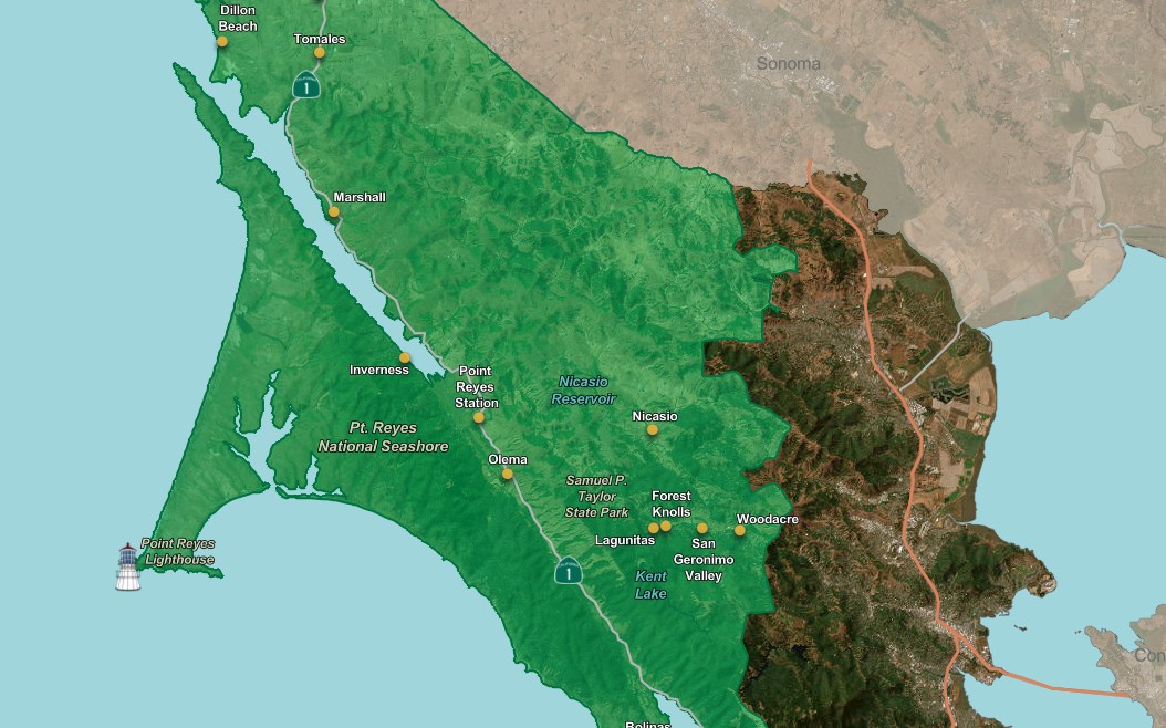
How do I get involved?
Community input is the foundation of this effort and will shape the vision. The project team will engage the public through a variety of inclusive outreach activities, starting with early community engagement this Summer 2026. Initial input will help shape a Request for Proposal (RFP) to find a project consultant to help with this initiative. For more information about the RFP, review the Frequently Asked Questions page.
We plan on hosting in-person meetings and opportunities for online engagement. We'll be announcing ways to participate as the project moves forward. Please stay tuned for upcoming chances to get involved and share your ideas.
Sign up for the listserv to receive timely updates and find out about upcoming engagement opportunities.
How else can I stay informed about this project?
Drafting the RFP is just the first step in this planning process. There will be many opportunities for you to participate throughout this process.
Sign up for the listserv to receive timely updates and find out about upcoming events.
Have a question or comment? Send us an email .
What is the project timeline?

|
||||
|---|---|---|---|---|
| Spring–Summer 2026 | Summer–Fall 2026 | Fall 2026 – Winter 2027 |
Winter –Spring 2027 | Spring-Summer 2027 |
|
|
|
|
|
|
|
|||
|
||||